Introduction
Have you ever been riding up a hill, and looked at your Garmin and seen that it thinks you’re going downhill? Has ClimbPro popped up, saying climb starting, when you’re already half way up it?
If the course you’re following originated on Strava, then you may have been hit by a Strava bug.
Lots of us create or use routes from Strava, and use the integration with Garmin so that any route that you favourite in Strava appears automatically on your Garmin bike computer. Its a really slick integration, however there is a bug that means routes transferred from Strava this way have an offset in elevation data.
What Causes the Bug in Garmin not showing climbs properly?
Cycling routes are made up of a series of GPS data points in a file, that define the route.
For each point, there is typically a latitude (north/south position) , and a longitude (east/west position) and an elevation figure (how high the point is from sea level), there can be a lot of other data added but that’s the minimum requirement.
A data point might look like this
   <trkpt lat="51.422540000000005" lon="-0.2832">
    <ele>37.22</ele>
   </trkpt>
Strava creates these points in the route every 50 metres or so.
However, when Strava transfers a route to Garmin Connect, it doesn’t just send the original route data, it creates a lot of additional data points, roughly 4 times as many as the original route.
In the process of creating these additional data points, the Strava code somehow manages to offset the elevation data.
This offset is what causes the elevation shown on your Garmin device to not match real life.
Workarounds
There are a couple of ways to work round this issue, neither are very convenient
- Transfer the route the old school way by downloading the GPX file from the Strava website and then copying it to the Garmin/Newfiles folder on your Garmin device.
- Use routes created somewhere other than Strava, such as in Garmin Connect
Manually transferring files requires a PC or Mac, the correct cables, and that you remember to Eject the Garmin device after transfer, otherwise the file system can become corrupted.
Why hasn’t Strava Fixed This?
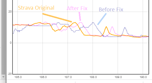
It’s not really obvious its a Strava issue, I originally thought it was a Garmin problem, so many people might be blaming Garmin. The issue used to be much worse, Strava released a patch back in April 2023 which reduced the offset but didn’t fix it. The image below shows the improvement, and that its not actually resolved.
I have an open ticket with them, but they haven’t done much with it. The ticket reference is 2638502 which you can mention if you want to raise your own ticket.
Where Can I find out More?
You can read the original thread I started on Garmin Connect and also GPLama did a video about it
You seem shifty, I don’t believe you
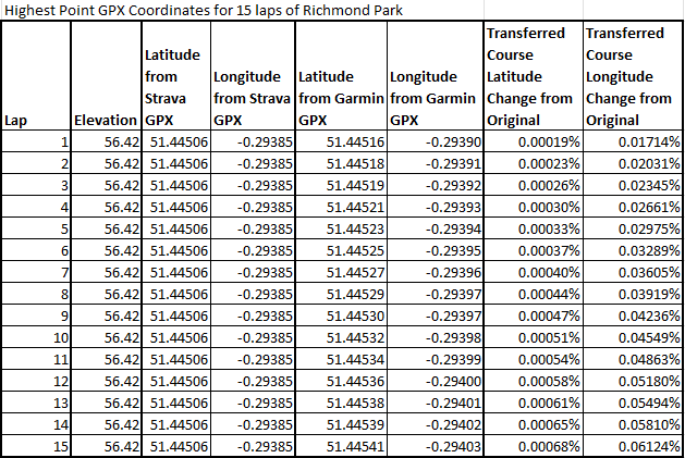
You can reproduce this yourself, details are in the Garmin forum thread. My most recent test was creating a route that just lapped Richmond Park 15 times. In the original Strava gpx file the highest point of 56.42m was always at exactly the same position as you’d expect, once the file was transferred to Garmin, the highest point moved around 2 metres on each lap, always in the same direction along the route.
https://www.strava.com/routes/3156224418575796774
2 Comments
Karl Jayasingha · November 5, 2023 at 5:38 pm
Great post Jeff. Do you think it will ever get fixed? It feels like it almost an accepted bug now.
Jeff Forrest · November 6, 2023 at 7:39 am
I hope so. I updated the ticket again and linked to the latest analysis.